Saturday, March 7, 2009

HIMACHAL PRADESH


Introduction to Himachal Pradesh

Himachal Pradesh is a part of the Indian Himalayas. It has wide valleys imposing snow mountains, limpid lakes, rivers and gushing streams. After India became free in 1947, a number of princely hilly states were integrated into a single unit to be administered by the Government of India. Himachal Pradesh came into being as a state of the India Union on April 15, 1948, by integrating 31 big and small hill states of the region. In 1956, it was converted into a Union Territory. Subsequently, some more hill areas of the Punjab state were added to this Union Territory and it was made into a full-fledged state, the status that it continues to have now. Himachal Pradesh today is one of the most important tourist destinations in India. The high hills of Himalayas welcome the trekkers from all over the world.

Geography of Himachal Pradesh

Uttaranchal on the southeast, Punjab on the west, China on the east, Haryana on the southwest, and Jammu and Kashmir on North of Himachal Pradesh. It extends from the latitudes 30°22’40” North to 33°12’40” North and longitudes 75°45' 55" East to 79°04' 20" East. The entire region of Himachal Pradesh is hilly with the altitude ranging from 350 meters to 7000 meters above sea level. The altitude increases from west to east and from south to north. Geographically, Himachal Pradesh can be divided into three distinct regions, the Shivalik or outer Himalayas, middle Himalayas or inner Himalayas, and greater Himalayas or the alpine zone.

Brief History of Himachal Pradesh

Himachal Pradesh region was called 'Deva Bhoomi'. In early period, tribes like the Koilis, Halis, Dagis, Dhaugris, Dasa, Khasas, Kinnars and Kirats inhabited it. The Aryan influence in this area of India dates to the period before the Rigveda. Sankar Varma, the king of Kashmir exercised his influence over regions of Himachal Pradesh in about 883 AD. This region witnessed the invasion of Mahmud of Ghazni in 1009 AD, who during that period invaded and looted the wealth from the temples in the North of India. In about 1043 AD the Rajputs ruled over this territory. Known for its vibrant and exquisite natural scenery it received the royal patronage of the Mughal rulers who erected several works of art as an appreciation of this land. In 1773 AD the Rajputs under Sansar Chand possessed this region, till the attack by Maharaja Ranjit Singh in 1804 which crushed the Rajput power here. The Gurkhas who migrated from Nepal captured this area and devastated it. In the early 19th century the British exercised their influence and annexed the areas of Shimla after the Gurkha War of 1815-16. It became a centrally administered territory in 1948 with the integration of 31 hill states and received additional regions added to it in 1966.

Government of Himachal Pradesh

In 2003, Indian National Congress won the elections for the legislative assembly and Virbhadra Singh became the Chief Minister of the state.

Districts of Himachal Pradesh

Himachal Pradesh has 12 districts: Bilaspur, Chamba, Hamirpur, Kangra, Kinnaur, Kullu, Lahaul-Spiti, Mandi, Shimla, Sirmaur, Solan and Una.

Economy of Himachal Pradesh

The economy of Himachal Pradesh is mainly dependent on tourism and apples. The state also has some natural minerals. It has two large cement factories, which not only caters to the people of Himachal but also sell their output to other states. Another major part of the Himachal economy is hydro electricity due to the abundance of perennial rivers. In spite of considerable challenge, the state has good connectivity through road, rail and air. Besides having the highest road density among all the hill states of India, it also has three airports and two narrow gauge rail tracks. The rapid developments in infrastructure by government and promotion of modern techniques of cultivation among the farmers, suitable agricultural machinery and good breeds of cattle, sheep and poultry made Himachal as one of the classic examples of rapid transformation from the most backward part of the country to one of its most advanced states. Himachal, now ranks fourth in respect of per capita income among the states of the Indian Union.

Himachal Pradesh Travel Information

Himachal Pradesh is the land of eternal snow peaks abounds in exotic valleys, glorious green hill-slopes, mountains, streams and the hills of Himalayas welcome the tourists from all over the world. Himachal Pradesh is full of hill resorts, pilgrimages, adventure sports destinations, and wildlife that attracts a wide range of tourist traffic. Today, Himachal Pradesh is one of the most important tourist destinations in India. It also has excellent trekking. Main tourist complexes are Shimla, Palampur, Dharamsala, Kulu-Manali, Chamba-Dalhousie. Temple at Bhima Kali, Sarahan, Hatkoti, Jwalajee, Chamunda Devi, Chintpurni, Renuka and Rewalsar, Deoth Siddh and Naina Devi are major attractions for pilgrims. Tourist complexes are also being set up at Keylong, Kaza, Sangla, Shoja, Kalpa, Khadrala, Kharapathar, Chindi, Bharmour, Chansal and Naggar castle. Hang-gliding competitions are held in Kangra valley. Solang Nallah slopes are getting popular for winter sports. There is an art gallery in Naggar and museums in Chamba, Shimla and Dharamasala. The beautiful tourist resort of Khajjair in Chamba district has been christened as the Switzerland of Himachal Pradesh.

Rivers of Himachal Pradesh

The major river systems of the region are the Chenab, the Ravi, the Beas, the Sutlej and the Yamuna. These perennial rivers are fed by snow and rainfall and are protected by a fairly extensive cover of natural vegetation.

Education of Himachal Pradesh

Himachal Pradesh was the summer capital during British Raj. Hence the standard of educations in the state has reached to a considerable level. The state has many educational institutes for higher studies. H.P. University and National Institute of Technology are pioneer institutes of the state. There are many other Universities - Chaudhary Sarwan Kumar Himachal Pradesh Krishi Vishwavidyalaya, Palampur; Dr. Y.S. Parmar University of Horticulture & Forestry, Nauni; Jaypee University of Information Technology, Solan and National Institute of Technology, Hamirpur. The overall literacy rate, according to census in 2001, is 77.13% with male literacy rate at 86.02% and female literacy rate at 68.08%.

Food of Himachal Pradesh

There are not many specific varieties that one can get in Himachal Pradesh. A long-time relationship with Punjab and large-scale migration of Tibetans ensured the impact of the Tibetan and Punjabi cuisine on Himachal. Some of the unique Himachali cuisines include Nasasta (a sweetmeat) in the Kangra region; Indra (made of Urad dal), Baadi / Ghaunda, and Bada/Poldu in the Shimla region; apart from favorites all over the state like Pateer, Chouck, Bhagjery and chutneys of Til. Non-vegetarian food is quite popular too in Himachal Pradesh.

Arts & Culture of Himachal Pradesh

Himachal dance forms are varied and some are quite complicated. These dances are an inseparable part of tribal life, which reflects the great perseverance and good humour of the human beings in the face of poverty and death. No festivity here is completed without dancing. The dance forms like Dulshol, Dharveshi, Drodi, Dev Naritya, Rakshas Nritya, Dangi, Lasa, Nati and Nagas are danced all over the state and provide a welcome break in the monotony of life.

The Himachalis in general have a highly developed sense of art, which is expressed in their objects of daily use. Their metal ware including attractive utensils, ritualistic vessels, idols and silver jewellery; the unglazed earthenware of Kangra; embroidered shawls and other garments which portray both classical and simple folk styles and designs; and traditional jewellery for almost all conceivable uses, are some of their popular crafts. Weaving of wool is a major cottage industry in itself.

Music& Dance of Himachal Pradesh

Most of the songs require no instrumental accompaniment. The themes are usually common ones like human love and separation of lovers. Some songs are about rituals. Chhinj, Laman, Jhoori, Gangi, Mohana and Tappe are love songs. Dholru is a seasonal song. Bare-Haren are ballads about warriors, Soohadiyan are songs sung at Childbirth. Losi and Pakkahad and Suhaag songs are all family songs, Karak are songs of praise in honour of the deities and Alhaini is a song of mourning. All these songs follow a specific style of singing and the geographical facts have a deep effect on these.

Costumes of Himachal Pradesh

The highlanders of Lahaul-Spiti and Kinnaur weave dresses from it for special occasions such as festivals and weddings. The wool products are made in either the Byangi wool. Sari is the most common garment that Himachali women wear. Traditional dresses like Kameez, Kurta, and Salwar in distinctive Himachali style are still popular. Women like to put on a coat or waistcoat during chilly winter days.

Monday, March 2, 2009

ASSAM:-THE LAND OF TEA AND ONE HORN RHINO


About UsAbout Assam


Introduction of Assam

Assam, the rich, green land of rolling plains, dense forests and beautiful rivers, It is the gateway to the north eastern part of India. Extending from and between the foot hills of the Eastern Himalayas and the Patkai and Naga Ranges, Assam is bordered by Bhutan in the North; Arunachal Pradesh in the East; Nagaland, Manipur and Mizoram in the south; Meghalaya in the South-West and Bengal and Bangladesh on the West.

Assam dominated by the mighty Brahmaputra River, is renowned for its tea, rich flora and fauna, the world famous one horned rhinoceros and other rare species of wildlife on the verge of extinction. It has mild winters and warm summers. Summer is from March to June and monsoon from July to August. November to February is winter. Best season to visit Assam is February to May.

Assam has drawn people from diverse cultures and races in different points of time. The main tourist attraction is the Kaziranga National Park, home of India's rare one-horned rhinoceros. The city of Guwahati is another place in the state which has in its vicinity numerous ancient Hindu temples and is reputed as an ideal place to explore the whole northeastern region. The capital Dispur is very near Guwahati. Other tourist destinations in the state are Hajo, Digboi, Manas, Jorhat, Tezpur, Sibsagar, Dibrugarh etc.

Important Places to visit in Assam :


Guwahati :

Guwahati is the commercial capital city of the northeastern state of Assam. Formerly known as Pragjyotishpur (the City of Eastern Light), Guwahati is the biggest city of Assam in India. Its etymological root is derived from two Assamese words, "Guwa," meaning areca nut and "Haat," meaning market. Fixed between the picturesque hills of the eastern flanks of the Himalayan mountain range, Guwahati houses the political capital of the state, Dispur. The gateway to the seven other northeastern states, also referred as seven sisters, Guwahati is a vital tourist base point, besides being an attraction in its own.

Digboi :

Digboi is known as the Oil City of Assam where the first oil well in Asia was drilled. The first refinery was started here as early as 1901. Digboi is the oldest oil well in operation. This place still retains the British ambience, complemented by the clubs and Golf courses nearby. Digboi in Assam is an oil town that can be traced to the early 18th century, when oil was first discovered here. Digboi can proudly boast of two unique features - a 100-year-old extant oilfield and the world's oldest operating oil refinery. Today, though the production is very low, Digboi still has the distinction of being the world’s oldest continuously producing oilfield. Digboi Assam oilfield is not another oilfield, but an oil museum with a history to be proud of.

Haflong :

Haflong is a hill station in Assam, situated at an altitude of 680 m from the sea level. Assam Haflong is famous for its scenic features comprising of azure blue hills, emerald green rivers, unique orchids such as Blue Vanda and rare species of birds. Haflong in Assam is often referred to as the land of blue hills. Inhabitants of Haflong generally include Himar, Mizo and Naga tribes. Pineapple and oranges are grown here in abundance. Haflong is best known for a lovely lakeside resort developed in the lavish green hills around the town.

Hajo :

Hajo in Assam is a centre for various religions, located about 28 km across the river Brahmaputra, from the city of Guwahati. Hajo in Assam is a sacred place, where three religions - Hindus, Muslims and Buddhists meets. Hajo is also renowned for its bell metal work. Hajo has a large number of temples, the chief among them being Hayagriva-Madhab Temple. Hajo Assam is also considered to be a Muslim pilgrimage centre, since the mosque known as the Pao Mecca built by Pir Ghiasuddin Aulia is situated here.

Majuli :

Majuli in Assam is perhaps the largest riverine island in the world, lie in the lap of the majestic Brahmaputra. The main attraction of Majuli Assam is its Satras. Out of 665 satras of Assam, 65 satras are housed by Majuli in Assam. Assam Majuli has sublime and serene atmosphere, a perfect environment in which the soul combines with elements. This has provided the back drop for the historic "Moni Kanchan Sanjog" between Assam's pioneer Vaishnavite Saints Shankerdeva and his disciple Madhabdeva in the 15th century. With the subsequent establishment of 'Satras', Majuli developed as the crowning glory of the Vaishnavite culture in Assam. Majuli Assam is a melting pot of different plain tribes possessing colourful and resourceful identities. The main tribes residing in Majuli are the Misings, the Deoris and Sonowal Kacharis.

Sibsagar :

Sibsagar is about 150 km east of the famous Kaziranga National Park, in the state of Assam. Sibsagar in Assam is the old capital of the Ahom Kings who ruled Assam for 600 years, until the British annexed the region in 1826. The town is built around the a large 129-acre artificial tank called the Sibsagar Lake (which had given the town its name), dug over 200 years ago. One can still find the archaeological remains, palaces, and temples of the Ahoms, now being preserved as national protected monuments. Today, Sibsagar is a rapidly developing town in commercial, industrial and educational activities. It is also an important centre for the tea and oil industries. But evidence of its royal past is overwhelming.

Festival of Assam

Bihu Festival


The Lively Celebration

“Bihu anondia, Bihu binondia
Bihur mou mitha hat
Bihur ba lagi bihua kokair e
Deu dhoni laguse gat.”

(Bihu is full of joy, Bihu is beautiful, Bihu songs are very sweet, when the winds of Bihu flow
The dancing spirit possesses one’s body).

The breathtaking hills and valleys of Assam come alive with the sound of Bihu thrice a year. A festival that marks the change of season, Bihu is accompanied both by prayer and great rejoicing. One of the seven northeastern states of India (which are also known as the Seven Sisters), Assam is renowned for its picturesque landscape, exotic fauna and fun-loving people.

Kaziranga National Park

Place: Jorhat Nawgaon & Golaghat districts, Assam

Best time to visit : November to April, closed during monsoon (April end to mid October)

Nearest town :
Bokaghat (23 km)

Main attraction : One Horned Rhinoceros, Wild Buffalo

Situated in Jorhat Nawgaon district, the Kaziranga National Park declared a World Heritage site by UNESCO in 1985, extends over an area of 430sq.km. It is bounded by the Mikir Hills on the South and Brahmaputra River on the north. The park, 217 km from the capital of Assam, Guwahati was declared a Wildlife sanctuary in 1950 and accorded the status of a National Park in 1974. The park divided into central, eastern and western sectors consists of semi- evergreen forested highlands, rivulets, marshes and extensive plains covered with tall elephant grass up to 6 metres high.

How to arrive in Assam

By Air : Assam is well connected to the major cities of India. Several domestic airlines fly to Assam. The Lokopriya Gopinath Bordoloi International Airport of Guwahati is well connected by air to most of the metros in the country. Air India also operates an international weekly flight between Bangkok and Guwahati.

By Rail :
The state of Assam has a convenient railway network both within the state and with the rest of the country. There are train services from Kolkata, New Delhi, Mumbai, Chennai, Bangalore, Cochin and Trivandrum. B.G. line connection is up to Dibrugarh and M.G. line with Haflong and Silchar. Major towns within the state are also connected by the railway network.

By Road :
Several private travel companies as well as the Assam State Transport Corporation operate a large network of buses around the state.


Map of Assam

Assam Map


Tea gardens

Exquisite and incredibly silent tea gardens are bliss for eyes. These are mainly located in the upper Assam and southern Barak Valley region. Serene and smiling tea gardens are one of the major tourist attraction. Enjoy the lush greenery of the undulating tea gardens on both sides of the highway while driving to different tea gardens is an exhilarating sightseeing.

Life at tea garden is oblivion to most of the outsiders.Trees are grown in bushes,the tea bushes are about 3 feet in height with an even surface from the top of which the pluckers pluck the tea leaves. The lay of the land in a tea garden is waving so that excess rainwater or irrigation water does not remain standing at the roots but flows away after watering the soil. Unfortunately, life of tea workers is worsening day by day, at least 700 tea workers have died from diseases link

INTRODUCTION TO JAMMU&KASHMIR

Location: The State of Jammu and Kashmir encompasses a mountainous region in the heart of Asia, with borders touching to both South and Central Asia. Surrounded by Pakistan, India, China and Afghanistan.

Area: 86,000 square miles, more than three times the size of the Netherlands, Luxembourg and Belgium combined. Bigger than 87 member countries of the United Nations.

Population: Estimated 13 million, including 1.5 million refugees in Pakistan and 0.5 million expatriates in different parts of the world. Larger than 114 sovereign nations.

Background: Technically, the area is called The State of Jammu and Kashmir, and has been historically independent, except in the anarchical conditions of the late 18th and the first half of the 19th century or when incorporated in the vast empires set up by the Mauryas (3rd century BC), the Mughals (16th to 18th centuries) and the British (mid-19th to mid-20th centuries).

Cause of Dispute: In 1846, the British colonial rulers of India sold the territory, including its populace (by a sale deed called the Treaty of Amritsar, in return for a sum of money) to a Hindu warlod who had no roots there. This warlord who bought himself into royalty, styled himself as the Maharajah of Jammu and Kashmir. The acts of brutality during his regime have left bitter memories, some of which persist to this present day. Several mosques were closed and occupied by his forces. The slaughtering of a cow was declared a crime punishable by death. Between 1925 and 1947 Maharajah Hari Singh continued this policy of discrimination against the 94 percent Muslim majority. It was nearly 65 years ago, in 1931, that the people of Kashmir made their first organised protest against Maharajah Hari Singh's cruelty. That led to the "Quit Kashmir" campaign against the Maharajah in 1946, and eventually to the Azad Kashmir movement which gained momentum a year later.

The first armed encounter between the Maharajah's troops and insurgent forces occurred in August 1947. At this time, Britain was liquidating its empire in the subcontinent. Faced with a insurgency of his people, strengthened by a few hundred civilian volunteers from Pakistan, Maharajah fled to Jammu on 25th October 1947. In Jammu, after he ascertained a commitment of military assistance from the government of India to crush the impending revolution in Kashmir, he signed the "Instrument of Accession" to India.

Lord Mountbatten conditionally accepted the "Instrument of Accession" on behalf of the British Crown, and furthermore, outlined the conditions for official acceptance in a letter dated 27th October 1947:

"In consistence with their policy that in the case of any (native) state where the issue of accession has been subject of dispute, the question of accession should be decided in accordance with the wishes of the people of the state, it is my government's wish that as soon as law and order have been restored in Kashmir and her soil cleared of the invaders the question of state's accession should be settled by a reference to the people."

Then Indian Prime Minister Jawaharlal Nehru, in a speech aired on All­India Radio (2nd November 1947), reaffirmed the Indian Government's commitment to the right of the Kashmiri people to determine their own future through a plebiscite:

"We have declared that the fate of Kashmir is ultimately to be decided by the people. That pledge we have given, and the Maharajah has supported it, not only to the people of Jammu and Kashmir, but also to the world. We will not and cannot back out of it. We are prepared when peace and law have been established to have a referendum held under international auspices like the United Nations. We want it to be a fair and just reference to the people and we shall accept their verdict."

The Government of India accepted the "Instrument of accession" conditionally, promising the people of the state and the world at large that "accession" would be final only after the wishes of the people of the state were ascertained upon return of normalcy in the state.

Following this, India moved her forces into Srinagar and a drawn­out fight ensued between Indian forces and the forces of liberation. The forces of Azad Kashmir successfully resisted India's armed intervention and liberated one­third of the State. Realising it could not quell the resistance, India brought the issue to the United Nations Security Council in January 1948. As the rebel forces had undoubtedly been joined by volunteers from Pakistan, India charged Pakistan with having sent "armed raiders" into the state, and demanded that Pakistan be declared an aggressor in Kashmir. Furthermore, India demanded that Pakistan stop aiding freedom fighters, and allowing the transit of tribesmen into the state.

After acceptance of these demands, coupled with the assurance that all "raiders" were withdrawn, India would enable a plebiscite to be held under impartial auspices to decide Kashmir's future status. In reply, Pakistan charged India with having manoeuvred the Maharajah's accession through "fraud and violence" and with collusion with a "discredited" ruler in the repression of his people. Pakistan's counter complaint was also coupled with the proposal of a plebiscite under the supervision and control of the United Nations to settle the dispute.

The Security Council exhaustively discussed the question from January until April of 1948. It came to the conclusion that it would be impossible to determine responsibility for the fighting and futile to blame either side. Since both parties desired that the question of accession should be decided through an impartial plebiscite, the Council developed proposals based on the common ground between them. These were embodied in the resolution of 21st April 1948, envisaging a cease­fire, the withdrawal of all outside forces from the State, and a plebiscite under the control of an administrator who would be nominated by the Secretary General. For negotiating the details of the plan, the Council constituted a five­member commission known as "United Nations Commission for India and Pakistan" (UNCIP) to implement the resolution.

After the cease­fire, India began efforts to drag the issue down, and under various pretexts tried to stop the UN resolution from being implemented. To this day, India pursues the same plan, and the resolution of 1948 has yet to be realised.

India and Pakistan were at war over Kashmir from 1947­48 and all early U. N. Security Council Resolutions contained admonishment for both countries demanding an immediate case­fire, which would be followed by a-UN directed Plebiscite. However, disregarding that some fifteen resolutions were passed by the United Nations to this very effect, India and Pakistan again initiated military skirmish in 1965. At this point, another cease­fire agreement was effected after United Nations intervention, followed by an agreement at Tashkent with the good offices of the USSR.

In 1971, India and Pakistan once again became locked in war. Efforts to bring the latest conflict to an end resulted in the Simla Agreement and was signed by both India and Pakistan and declared commitment to reach a "final settlement" on the Kashmir issue, but this has yet to happen.

Sunday, March 1, 2009

iNTRODUCTION

"So far as I am able to judge, nothing has been left undone, either by man or nature, to make India the most extraordinary country that the sun visits on his rounds. Nothing seems to have been forgotten, nothing overlooked." --Mark Twain, from Following the Equator

It is impossible not to be astonished by India. Nowhere on Earth does humanity present itself in such a dizzying, creative burst of cultures and religions, races and tongues. Every aspect of the country presents itself on a massive, exaggerated scale, worthy in comparison only to the superlative mountains that overshadow it. Perhaps the only thing more difficult than to be indifferent to India would be to describe or understand India completely.

Location, Geography, & Climate

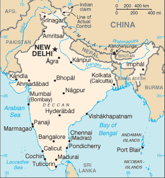
Set apart from the rest of Asia by the supreme continental wall of the Himalayas, the Indian subcontinent touches three large bodies of water and is immediately recognizable on any world map. It is the huge, terrestrial beak between Africa and Indonesia. This thick, roughly triangular peninsula defines the Bay of Bengal to the east, the Arabian sea to the west, and the India Ocean to the south.

India's puzzleboard of 26 states holds virtually every kind of landscape imaginable. An abundance of mountain ranges and national parks provide ample opportunity for eco-tourism and trekking, and its sheer size promises something for everyone. From its northernmost point on the Chinese border, India extends a good 2000 miles (3200 km) to its southern tip, where the island nation of Sri Lanka seems to be squeezed out of India like a great tear, the synapse forming the Gulf of Mannar. India's northern border is dominated mostly by Nepal and the Himalayas, the world's highest mountain chain. Following the sweeping mountains to the northeast, its borders narrow to a small channel that passes between Nepal, Tibet, Bangladesh, and Bhutan, then spreads out again to meet Burma in area called the "eastern triangle." Apart from the Arabian sea, its western border is defined exclusively by Pakistan.

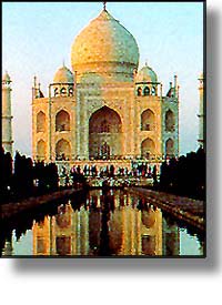
India can be organized along the compass points. North India, shaped like a throat and two lungs, is the country's largest region. It begins with the panhandle of Jammu and Kashmir, a dynamic area with terrain varying from arid mountains in the far north to the lake country and forests near Sringar and Jammu. Falling south along the Indus river valley, the North becomes flatter and more hospitable, widening into the fertile plains of Punjab to the west and the Himalayan foothills of Uttar Pradesh and the Ganges river valley to the East. Cramped between these two states is the capital city, Delhi. The southwestern extremity of the North is the large state of Rajastan, whose principal features are the Thar Desert and the stunning "pink city" of Jaipur. To the southeast is southern Uttar Pradesh and Agra, home of the famous Taj Mahal.

West India contains the states of Gujarat, Maharashtra, Goa, and part of the massive, central state of Madhya Pradesh. The west coast extends from the Gujarat peninsula down to Goa, and it is lined with some of India's best beaches. The land along the coast is typically lush, with rainforests reaching southward from Bombay all the way to into Goa. A long mountain chain, the Western Ghats, separates the verdant coast from the Vindya mountains and the dry Deccan plateau further inland.

Home of the sacred Ganges river and the majority of Himalayan foothills, East India begins with the states of Madhya Pradesh, Bihar, Orissa, which comprise the westernmost part of the region. East India also contains an area known as the eastern triangle, which is entirely distinct. This is the last gulp of land that extends beyond Bangladesh, culminating in the Naga Hills along the Burmese border.

India reaches its peninsular tip with South India, which begins with the Deccan in the north and ends with Cape Comorin, where Hindus believe that bathing in the waters of the three oceans will wash away their sins. The states in South India are Karnataka, Andhra Pradesh, Tamil Nadu, and Kerala, a favorite leisure destination. The southeast coast, mirroring the west, also rests snugly beneath a mountain range---the Eastern Ghats.

Because of India's size, its climate depends not only on the time of year, but also the location. In general, temperatures tend to be cooler in the north, especially between September and March. The south is coolest between November to January. In June, winds and warm surface currents begin to move northwards and westwards, heading out of the Indian Ocean and into the Arabian Gulf. This creates a phenomenon known as the south-west monsoon, and it brings heavy rains to the west coast. Between October and December, a similar climatic pattern called the north-east monsoon appears in the Bay of Bengal, bringing rains to the east coast. In addition to the two monsoons, there are two other seasons, spring and autumn.

Though the word "monsoon" often brings to mind images of torrential floods and landslides, the monsoon seasons are not bad times to come to India. Though it rains nearly every day, the downpour tends to come and go quickly, leaving behind a clean, glistening landscape.


Culture & People

With nearly 1 billion citizens, India is the second most populous nation in the world. It is impossible to speak of any one Indian culture, although there are deep cultural continuities that tie its people together. English is the major language of trade and politics, but there are fourteen official languages in all. There are twenty-four languages that are spoken by a million people or more, and countless other dialects. India has seven major religions and many minor ones, six main ethnic groups, and countless holidays.

Religion is central to Indian culture, and its practice can be seen in virtually every aspect of life in the country. Hinduism is the dominant faith of India, serving about 80 percent of the population. Ten percent worship Islam, and 5 perscent are Sikhs and Christians; the rest (a good 45 million) are Buddhists, Jains, Bahai, and more.